The Habitat Biodiversity Audit, or HBA, was established in 1995 to provide up to date records of habitats and land use changes over time in Warwickshire. This world leading project is the longest continuously running survey of its kind in the UK, and provides invaluable information for local councils and landowners.
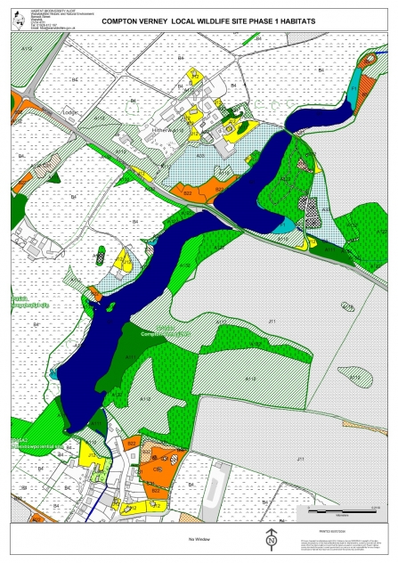
Every year HBA staff and volunteers undertake two kinds of habitat surveys. Phase 1 surveys began in 1995 and have been collected continuously for 25 years. Survey results are mapped in specialist software and used to inform local planning decisions, green and blue infrastructure, and to identify potential local wildlife sites. The resulting maps have also been used for academic research and wildlife projects, and the HBA team provide reports to local parish councils and businesses on what wildlife lives in their patch.
More detailed Phase 2 habitat surveys began around 2000 and are used to further classify habitats of potential nature conservation value and inform the location of nature reserves, as well as helping local authorities and farmers manage their land. As a result of this information 24 local Biodiversity Action Plans have been created to provide clear targets for protecting vital habitats and to connect local people who can deliver action.
The survey season usually begins in April each year when plants are in flower and become more easily identifiable. HBA staff train both a core team of volunteers and ecological graduates in survey techniques, providing valuable field experience. The volunteers need only an interest in plant identification and good map reading skills to be useful assets to the survey team.
Despite a challenging year in 2020, when almost no surveying was possible due to Covid-19, the team have consistently delivered ecological information and reports for green infrastructure planning and acted as a vital source of information for scientific research.
The techniques developed by the HBA over the past 25 years are an excellent example of how joined-up, nature-rich spaces of all sizes can be mapped and used to identify areas which need our help. The UK faces an ecological crisis and for nature to recover we need local Nature Recovery Network maps to identify where good wildlife habitat is already, where it should be and how it will be created, restored, and joined together to achieve recovery. Such maps could then be used for local planning and infrastructure decisions and more.
The HBA partnership is managed by Warwickshire Wildlife Trust and was founded by six Warwickshire local authorities plus Solihull and Coventry unitary authorities, Natural England and the Environment Agency.

